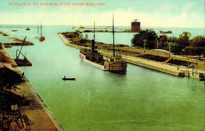
Entrance to Port Colborne Harbour
Description
- Media Type
- Image
- Item Type
- Images, Electronic
- Description
- Photo of the Port Colborne harbour and Gravelly Bay, the Welland Canal southern terminus on Lake Erie, during the third canal era.
- Notes
- The current lighthouse on the west breakwater, and the former lighthouse on the west pier, used during the third canal era, can both been seen in this photo.
- Date of Original
- c. 1903 - 1906
- Local identifier
- 995.12.1
- Language of Item
- English
- Geographic Coverage
-
-
Ontario, Canada
Latitude: 42.874222 Longitude: -79.249073
-
- Copyright Statement
- Copyright status unknown. Responsibility for determining the copyright status and any use rests exclusively with the user.
- Contact
- Port Colborne Historical and Marine MuseumEmail:archives@portcolborne.ca
Website:
Address:280 King St. Box 572
Port Colborne, ON L3K 5X8


