LHM060 Wall Map of County of Ontario, North Portion
Description
- Media Type
- Image
- Item Type
- Maps
- Description
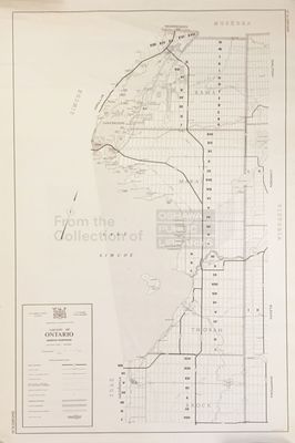
- A map of the north portion of Ontario County, from Brock to Rama Townships.
- Notes
- Scale on map listed as 1" to 1 mile
- Publisher
- Department of Highways, Ontario
- Date of Original
- June 1969
- Dimensions
-
Width: 27 in
Height: 42 in
- Local identifier
- LHM060
- Language of Item
- English
- Copyright Statement
- Copyright status unknown. Responsibility for determining the copyright status and any use rests exclusively with the user.
- Location of Original
- Map Drawer 5
- Terms of Use
- please credit Oshawa Public Libraries, Local History Collection
- Contact
- Oshawa Public LibrariesEmail:nadams@oshawalibrary.on.ca
Website:
Agency street/mail address:
Nicole Adams, Local History and Genealogy Librarian
65 Bagot Street
Oshawa, ON L1H 1N2
905-579-6111 EXT 5253