Plan of the King's Highway in the Township of Clinton, County of Lincoln.
Description
- Media Type
- Image
- Item Type
- Maps
- Description
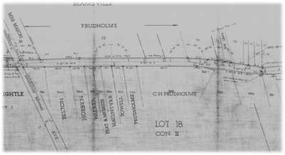
- A map of Highway 8 between Vineland and Beamsville, in the current Town of Lincoln. The map is about 37cm wide by about 6m long. Names of land owners (and in many cases, former owners) are shown, along with the exact frontage of each property.
- Notes
- The survey is dated Dec. 31, 1932, and the map is dated Feb. 20, 1934.
Drawing No. P-1935 - Publisher
- Department of Highways - Ontario
- Place of Publication
- Toronto
- Date of Original
- 1934
- Date Of Event
- 1932
- Map Scale
- 1
- Subject(s)
- Language of Item
- English
- Geographic Coverage
-
-
Ontario, Canada
Latitude: 43.158 Longitude: -79.4126129150391
-
- Copyright Statement
- Copyright status unknown. Responsibility for determining the copyright status and any use rests exclusively with the user.
- Contact
- Lincoln Pelham Public LibraryEmail:admin@lppl.ca
Website:
Agency street/mail address:4080 John Charles Blvd.,
Vineland, Ontario L0R 2C0