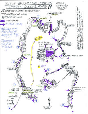
Eugenia Cottager's Association "War on Loosestrife" map
Description
- Creators
- Heather Davidson, Artist
- Nancy Matthews, Artist
- Media Type
- Image
- Text
- Item Type
- Drawings
- Description
- Strategic map developed for the eradication of an imported flower called Purple Loosestrife which had invaded the wetlands surrounding Lake Eugenia, threatening native plants and the ecosystem.
- Date of Original
- August 12, 1995
- Date Of Event
- August 12, 1995
- Dimensions
-
Width: 8.5 in
Height: 11 in
- Subject(s)
- Local identifier
- Loosestrife_Map
- Collection
- Split Rail Country Volume 2
- Language of Item
- English
- Geographic Coverage
-
-
Ontario, Canada
Latitude: 44.3168 Longitude: -80.5164
-
- Copyright Statement
- Copyright status unknown. Responsibility for determining the copyright status and any use rests exclusively with the user.
- Contact
- Grey Highlands Public LibraryEmail:contact@greyhighlandspubliclibrary.com
Website:
Agency street/mail address:101 Highland Drive
Box 280 Flesherton, ON
519-924-2241


