Results
- Chronicle-Journal, 8 Dec 2016, A5 Full text available on microfilmChronicle-Journal, 8 Dec 2016, A5 Full text available on microfilm
- Chronicle-Journal, 15 Nov 2017, A1 Full text available on microfilmChronicle-Journal, 15 Nov 2017, A1 Full text available on microfilm
- Chronicle-Journal, 13 Jan 2017, A3 Full text available on microfilmChronicle-Journal, 13 Jan 2017, A3 Full text available on microfilm
- Chronicle-Journal, 10 May 2017, A1 Full text available on microfilmChronicle-Journal, 10 May 2017, A1 Full text available on microfilm
- Chronicle-Journal (Thunder Bay), 26 Apr 2022, A1, A3 Full text available at the Brodie Resource LibraryChronicle-Journal (Thunder Bay), 26 Apr 2022, A1, A3 Full text available at the Brodie Resource Library
- Chronicle-Journal (Thunder Bay), 10 May 2022, A5 Full text available at the Brodie Resource LibraryChronicle-Journal (Thunder Bay), 10 May 2022, A5 Full text available at the Brodie Resource Library
- Chronicle-Journal (Thunder Bay), 27 Dec 2022, A3 Full text article is available at the Brodie Resource LibraryChronicle-Journal (Thunder Bay), 27 Dec 2022, A3 Full text article is available at the Brodie Resource Library
- Chronicle-Journal (Thunder Bay), 11 Jul 2024, A3 Full text available on microfilm at the Brodie Resource LibraryChronicle-Journal (Thunder Bay), 11 Jul 2024, A3 Full text available on microfilm at the Brodie Resource Library
- The spring of 1908 was a season of extremes with May temperatures in the mid 80's. In the middle of May, the rains came, causing streams to swell. Shortly before midnight on May 27 a 200 million cubiThe spring of 1908 was a season of extremes with May temperatures …
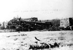
- Photo showing the swollen Current River. The flood of 1908 caused the loss of lives, power outages, and destruction of property, making it one of the Lakehead's greatest tragedies.Photo showing the swollen Current River. The flood of 1908 caused the …
- Photo showing the damage done to the flumes, as a result of the flooding of the Current River, May 27, 1908.Photo showing the damage done to the flumes, as a result of …
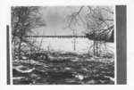
- Photograph (b&w) showing the water descending at the Current River Dam, Port Arthur. The water appears to be unusually high and flooding the area.Photograph (b&w) showing the water descending at the Current River Dam, Port …
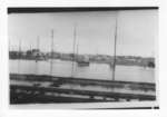
- A view of the East End from the railroad tracks after flooding has occurred in 1941.A view of the East End from the railroad tracks after flooding …
- Fort William Daily Times Journal, 25 Apr 1957, p. 1 Full text available on microfilmFort William Daily Times Journal, 25 Apr 1957, p. 1 Full text available on microfilm
- Thunder Bay Source, 29 Mar 2018, p. 4 Full text available at Brodie Resource LibraryThunder Bay Source, 29 Mar 2018, p. 4 Full text available at Brodie Resource Library
- Fort William Daily Times Journal, 21 Apr 1961 Full text available on microfilmFort William Daily Times Journal, 21 Apr 1961 Full text available on microfilm
- Chronicle-Journal (Thunder Bay), 11 May 2024, A3 Full text article is available at the Brodie Resource LibraryChronicle-Journal (Thunder Bay), 11 May 2024, A3 Full text article is available at the Brodie Resource Library
- Chronicle-Journal, 5 Jul 2016, A3 Full text available on microfilmChronicle-Journal, 5 Jul 2016, A3 Full text available on microfilm
- Chronicle-Journal, 5 May 2016, A1 Full text available on microfilmChronicle-Journal, 5 May 2016, A1 Full text available on microfilm


