Port Arthur Ore Dock #16
Description
- Media Type
- Image
- Item Type
- Photographs
- Description
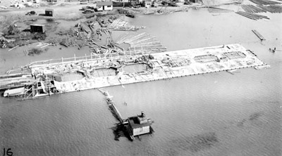
- Black and white aerial (#16) photo showing the first layer of the ore dock above water.
- Date of Original
- August 2 1944
- Subject(s)
- Local identifier
- TBPL:#16 in photo album in Special Collections
- Geographic Coverage
-
-
Ontario, Canada
Latitude: 48.4001 Longitude: -89.31683
-
- Copyright Statement
- Copyright status unknown. Responsibility for determining the copyright status and any use rests exclusively with the user.
- Contact
- Thunder Bay Public LibraryEmail:research@tbpl.ca
Website:
Agency street/mail address:Brodie Resource Library
216 South Brodie Street
Thunder Bay, ON
P7E 1C2