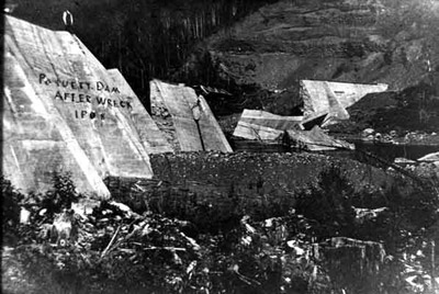
Paquette Dam (1908)
Description
- Media Type
- Image
- Item Type
- Photographs
- Description
- Photo showing the destruction to the Paquette Dam caused by heavy rains and flooding of the Current River., The rains poured from mid May, swelling streams already engorged by sudden spring runoff. At the foot of a steep valley, a few miles downstream from the Onion Lake Dam, the smaller Paquette Dam, eroded and undermined, began to give way under the extra burden., The Paquette Dam was never rebuilt.
- Date of Original
- 1908
- Image Dimensions
-
Image Width: 5.5
Image Height: 3.5
- Subject(s)
- Local identifier
- P1161
- Collection
- Thunder Bay Public Library
- Geographic Coverage
-
-
Ontario, Canada
Latitude: 48.4501 Longitude: -89.18341
-
- Copyright Statement
- Public domain: Copyright has expired according to Canadian law. No restrictions on use.
- Contact
- Thunder Bay Public LibraryEmail:research@tbpl.ca
Website:
Agency street/mail address:Brodie Resource Library
216 South Brodie Street
Thunder Bay, ON
P7E 1C2


