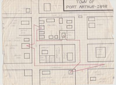
Hand drawn map of Port Arthur -1898
Description
- Media Type
- Image
- Text
- Item Type
- Drawings
- Description
- This map of Port Arthur in 1898 was drawn by Archibald McDougall to show where the telegraph lines ran at that date. The red lines indicate the telegraph lines. Mr. McDougall’s sister was the telegraph operator at the time, and the telegraph lines ran into the McDougall home where Miss McDougall worked as telegraph operator from the attic of the home. The map also indicates the location of homes and names of residents of Port Arthur on that date. Archibald McDougall spent over 70 years in telecommunications in Thunder Bay starting as a lineman for the telegraph company, then working as a lineman for the Fort William Telephone Department in its early years, and then as Manager of the Fort William Telephone Department for many years. His son (my father) Wallace Elward McDougall was also Manager of the Thunder Bay Telephone Department as well as past president of the Canadian Independent Telephone Association.
- Date of Original
- 1898
- Date Of Event
- 1898
- Subject(s)
- Donor
- Carol Mcdougall
- Creative Commons licence
 [more details]
- Copyright Statement
- Copyright status unknown. Responsibility for determining the copyright status and any use rests exclusively with the user.
- Contact
- Thunder Bay Public LibraryEmail:research@tbpl.ca
Website:
Agency street/mail address:Brodie Resource Library
216 South Brodie Street
Thunder Bay, ON
P7E 1C2


