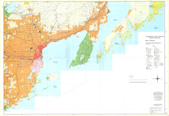
Thunder Bay
Description
- Media Type
- Image
- Item Type
- Maps
- Description
- Recreation Maps ; Thunder Bay ; Sleeping Giant Provincial Park ; Provincial Parks ; Lake Superior Archipelego Conservation Reserve ; Snowmobile Trails ; Recreation Trails
- Notes
- CrimeStoppers - North of Superior Explorer Map Series
Map housed at the Brodie Resource Library - Inscriptions
- This map includes Thunder Bay, Sleeping Giant Provincial Park, Black Bay and portions of wildlife management units 13 and 14
- Publisher
- Kestral Forestry
- Place of Publication
- Thunder Bay
- Date of Publication
- 2000
- Map Scale
- 1:130,000
- Subject(s)
- Corporate Name(s)
- Crime Stoppers ; North of Superior Tourist Association
- Local identifier
- Map 2
- Collection
- Maps
- Language of Item
- English
- Geographic Coverage
-
-
Ontario, Canada
Latitude: 48.665555 Longitude: -88.461944 -
Ontario, Canada
Latitude: 48.244444 Longitude: -89.098333 -
Ontario, Canada
Latitude: 48.4168 Longitude: -88.75008 -
Ontario, Canada
Latitude: 48.401388 Longitude: -89.267777
-
- Copyright Statement
- Protected by copyright: Uses other than research or private study require the permission of the rightsholder(s). Responsibility for obtaining permissions and for any use rests exclusively with the user.
- Copyright Date
- 2000
- Copyright Holder
- Thunder Bay District Crime Stoppers Inc., North of Superior Tourism, The Friends of Northern Lights Country
- Contact
- Thunder Bay Public LibraryEmail:research@tbpl.ca
Website:
Agency street/mail address:Brodie Resource Library
216 South Brodie Street
Thunder Bay, ON
P7E 1C2