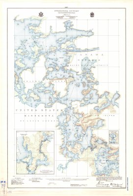
International Boundary from the Northwesternmost point of Lake of the Woods to Lake Superior -- Sheet No. 18
Description
- Media Type
- Image
- Item Type
- Maps
- Description
- Boundary Maps ; Rainy River District Maps ; Lac LaCroix
- Notes
- Map housed at the Brodie Resource Library
- Inscriptions
- We certify that this map is one of the quadruplicate set of thirty-six maps prepared under Article V of the Treaty between Great Britain and the United States of America, signed at Washington, April 11, 1908, and that we have marked hereon the Boundary Line as reestablished by the Commissioners designated above in accordance with provisions of the said Treaty. Signed October 29,1928.
- Publisher
- Printed by U.S. Geological Survey
- Place of Publication
- Washington, D.C.
- Date of Publication
- 1928
- Map Scale
- 1:24,000
- Subject(s)
- Corporate Name(s)
- Engraved by Williams-Webb Co., Inc.
- Local identifier
- IB 18
- Collection
- Maps
- Language of Item
- English
- Geographic Coverage
-
-
Ontario, Canada
Latitude: 48.374 Longitude: -92.16108
-
- Copyright Statement
- Copyright status unknown. Responsibility for determining the copyright status and any use rests exclusively with the user.
- Contact
- Thunder Bay Public LibraryEmail:research@tbpl.ca
Website:
Agency street/mail address:Brodie Resource Library
216 South Brodie Street
Thunder Bay, ON
P7E 1C2


