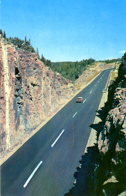
Postcards of North Shore
Description
- Creator
- Alutone Reproductions by E.S. & A. Robinson (Canada) Limited, Leaside, Ontario
- Media Type
- Image
- Item Type
- Postcards
- Description
- Canadian Lake Superior Post Card Series
- Notes
- The Cavers Hill Rock cut on the Trans Canada Highway. This cut is 717 feet in length and involved 62,527 cubic yards of rock excavation. The maximum depth of the cut is 60 feet.
- Publisher
- Dan Gibson
- Place of Publication
- Toronto, Canada
- Pagination
- p. 382
- Dimensions
-
Width: 3.5 in
Height: 5.5 in
- Subject(s)
- Local identifier
- tbl_pc
- Collection
- Postcards of North Shore
- Language of Item
- English
- Geographic Coverage
-
-
Ontario, Canada
Latitude: 48.78341 Longitude: -87.09996
-
- Donor
- Larry Driffield
- Copyright Statement
- Public domain: Copyright has expired according to Canadian law. No restrictions on use.
- Copyright Holder
- Terrace Bay Public Library
- Copyright Holder Contact Information
- 13 Selkirk Avenue Terrace Bay, ON P0T 2W0
- Recommended Citation
- Please cite the Terrace Bay Public Library and the Publisher Source.
- Contact
- Terrace Bay Public LibraryEmail:library@terracebay.ca
Website:
Agency street/mail address:13 Selkirk Ave. P.O. Box 369
Terrace Bay, ON P0T 2W0
807-825-3315 x222


