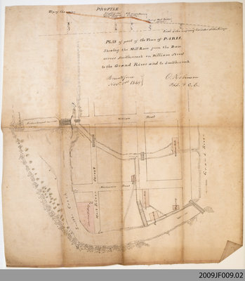
Plan of Paris showing the Nith River Area, 1869
Description
- Creator
- Robinson, O., Cartographer
- Media Type
- Image
- Item Types
- Maps
- Plans
- Description
- This 1869 plan shows the area surrounding the Nith River (then Smiths Creek) at the corners of West River and Mechanic Streets, from the dam and millrace on the Nith to the Grand River at William Street.
A number of period landmarks are indicated on the map. These include the "old dam" and enbankment; the Hamilton, Willow and Whitlaw Mills; the plaster mill; Mitchell's shop; Aherns's Pottery; and Finlayson's tannery. - Notes
- This item was digitized on November 14th, 2009, during a Digitization Days event at the Paris Branch of the County of Brant Public Library.
- Date of Original
- 1869
- Subject(s)
- Local identifier
- 2009JF009
- Collection
- Jayme Frazee-Wright Collection
- Language of Item
- English
- Geographic Coverage
-
-
Ontario, Canada
Latitude: 43.1917507586337 Longitude: -80.3862011432648
-
- Donor
- Property of Jayme Frazee-Wright
- Copyright Statement
- Copyright status unknown. Responsibility for determining the copyright status and any use rests exclusively with the user.
- Contact
- County of Brant Public LibraryEmail:digitalhistory@brant.ca
Website:
Agency street/mail address:County of Brant Public Library (Paris Branch)
12 William Street
Paris, ON
N3L 1K7 | @brantlibrary


