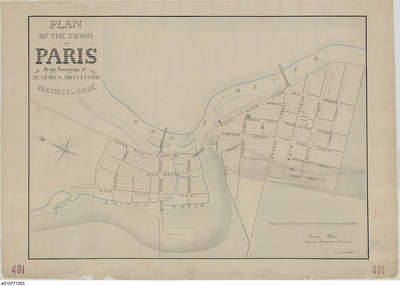
Plan of the Town of Paris, 1847
Description
- Creators
- F. Herbst, Cartographer
- Allchin, Thomas, Surveyor
- Media Type
- Image
- Text
- Item Types
- Maps
- Plans
- Description
- This is the earliest existing town plan of Paris, which was created in 1847 by F. Herbst based on a survey by Thomas Allchin, the deputy provincial surveyor. The earliest town plan was prepared by Lewis Burwell, but no copies are known to exist.
The plan shows all of the land then considered to fall within the borders of Paris, and numbers each lot individually. - Inscriptions
- PLAN
OF THE TOWN
OF
PARIS
In the Townships of
DUMFRIES, BRANTFORD
DISTRICT of GORE - Date of Original
- 1847
- Dimensions
-
Width: 25 in
Height: 18 in
- Map Scale
- 1 inch to 4 chains
- Subject(s)
- Local identifier
- NMC 0022692
- Language of Item
- English
- Geographic Coverage
-
-
Ontario, Canada
Latitude: 43.2 Longitude: -80.38333
-
- Donor
- Based on a plot by F. Herbst and Thomas Allchin provided by Library and Archives Canada, reproduction copy number NMC 0022692.
- Copyright Statement
- Public domain: Copyright has expired according to Canadian law. No restrictions on use.
- Copyright Date
- 1847
- Recommended Citation
- Library and Archives Canada, H2, 440, record number 16606, reproduction copy number NMC 0022692.
- Reproduction Notes
- Reuse of this image should include the credit line to Library and Archives Canada specified in the recommended citation.
- Contact
- County of Brant Public LibraryEmail:digitalhistory@brant.ca
Website:
Agency street/mail address:County of Brant Public Library (Paris Branch)
12 William Street
Paris, ON
N3L 1K7 | @brantlibrary


