Abstract of Title to Lot 30 West of the Grand River, with Map
Description
- Creator
- Shenston, T.S., Author
- Media Type
- Text
- Image
- Item Types
- Documents
- Maps
- Description
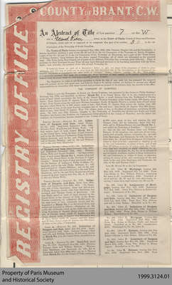
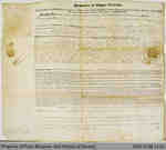
- This abstract of title provides the transactional history of the portions of Lot 30 in Dumfries, which had at various times belonged to Thomas Clark, William Dickson, John Holme, Samuel Street and Hiram Capron. It was prepared in 1855 at the time of the incorporation of Paris in order to assess an accurate picture of land division and ownership. Unlike the “Abstract of Title to Gore North of Dundas Street” (item number 1999.9024.01), this abstract includes the map of the lot referred to in its text.
- Pagination
- p. 1-5
- Date of Original
- 1855
- Subject(s)
- Local identifier
- 1999.3124.01 - 05
- Collection
- Hiram Capron Collection
- Language of Item
- English
- Geographic Coverage
-
-
Ontario, Canada
Latitude: 43.2 Longitude: -80.38333
-
- Copyright Statement
- Public domain: Copyright has expired according to Canadian law. No restrictions on use.
- Recommended Citation
- Abstract of Title to Lot 30 West of the Grand River, 1855, Hiram Capron Collection, 1999.3124.01-03, Paris Museum and Historical Society
- Terms of Use
- The information and images provided are for personal research only and are not to be used for commercial purposes. Use of this information should include the credit “Paris Museum and Historical Society.”
- Contact
- Paris Museum and Historical SocietyEmail:info@theparismuseum.com
Website:
Agency street/mail address:Paris Museum and Historical Society
51 William Street, Paris, ON
N3L 1N4
(519) 442-9295
- Full Text
REGISTRY OFFICE
COUNTYofBRANT.C.W.
An Abstract of Title of Lot number 7 on the W side of Grand River street, in the Town of Paris, County of Brant and Province of Ontario, which said lot is supposed to be composed of a part of lot number 30 in the 1st Concession of the Township of South Dumfries.
The Town of Paris became incorporated May 19th, 1855, 18th Victoria, Chapter 148, and the boundaries, a therein described, embrace a part of lots 29, 30, and 31 in the 1st Concession of the TOWNSHIP OF SOUTH DUMFRIES, a part of lots No. 12 and 13 in the 1st Concession of the TOWNSHIP OF BRANTFORD, and a part of the "GORE NORTH of DUNDAS STREET," lying between the two above named Townships, all of which are delineated on the annexed map. The Town being thus formed out of pars of six different Township lots, occasions great difficulty. First, to ascertain to what township lot any Town lot may have belonged previous to its becoming associated with the Town limits; and, secondly, the position of the title of such Township lot.
It certainly forms no part of a Registrar's duties to plot out maps of the properties of which he gives abstracts, and, if it was, it could not be done from the data furnished him by the descriptions in the documents he records, inasmuch as boundaries are often made of "stumps," "trees," "stones," "creeks," &c., &c. Then again, it is generally assumed that each lot contains the EXACT QUANTITY of land named in the patent, whereas in fact almost every lot FALLS SHORT OR OVER RUNS a goodly number of acres.
The Registrar, in order to aid those requiring to know the title of any such lot, has prepared the annexed map and printed sheets with great care, and believes them to be strictly correct, yet declines to assume any official responsibilities in connection with them beyond such portions as purport to be extracts from the records in his office.
THE TOWNSHIP OF DUMFRIES
Which is now the TOWNSHIP OF NORTH AND SOUTH DUMFRIES, was patented by the Crown to Philip Stedman' February 5th, 1798, and described as follows : Block No. 1 on GRAND RIVER, that is to say, commencing at a point of land which constitutes the forks of the Grand River, a small distance from the Northward of Dundas street; from thence South 77 degrees West to the most Western boundary of the Indian lands, 250 chams, more or less; from thence along the said most Western boundary, North 16 degrees West to a certain tract of land which has been called Block No. 2, 980 chains more or less; then North 77 degrees East across the Indian trail, 960 chains more or less, to the most Eastern boundary line of the said trail; then South 16 degrees East 980 chains, more or less; then South 77 degrees West 710 chains, more or less, to the place of beginning, containing 94,305 acres. By 14th and 15th Victoria, Chapter 5, the Township of Dumfries was divided into North and South Dumfries, the former (the Northern six Concessions) being attached to the country of waterloo, and the latter (the southern six Concessions) became attached to the County of Brant.
(Left column)
TORONTO RECORD.- Memorial No. 152. Indenture of Bargain and Sale, dated December 4th, 1802. Registered September 24th, 1805. Between Peter Hogeboom and Elisha Wells. "All that certain tract of land, named Block No. 1 on the Grand River, being the tract of land formerly sold by the Six Nations of Indians to Philip Stedman, Junior, deceased, and by the said Philip Steadman sold to Charles Whitney, and by the said Whitney sold to the said Peter Hogeboom."
TORONTO RECORD.- Memorial No. 166. Indenture of Bargain and Sale, dated February 11th, 1805. and Registered December 14th, 1805. Between Elisha Wells and Daniel Penfield. "All that certain tract of land named Block No. 1, situate, lying and being on the Grand River, in the Province of Upper Canada." Being the tract of land previously sold by the Six Nations of Indians to Philip Steadman Jr., deceased, and by the said Philip Stedman, Jr., sold and conveyed to Charles Whitney, and by the said Charles Whitney sold and conveyed to the said Peter Hogeboom, and by the said Peter Hogeboom sold and conveyed by deed, bearing date Dec. 4th A.D. 1802, to the said Elisha Wells.
TORONTO RECORD.- Memorial No. 1765. Indenture of Bargain and Sale , dated June 26th, 1811, and Registered June 29th, 1811. "By Susannah, wife of John Sparkman, sister and heir-at-law of Philip Stedman, jointly with John Sparkman, her husband, unto Thomas Clark, of Queenston. "All that Block, parcel or tract of land, situated on the Grand River, in the County of York, in the Home District, containing by estimation 94,305 acres, be the same more or less, commonly known and distinguished as Block No. 1 on the Grand River, and butted and bounded as follows :- Beginning on the north side of Dundas street, at the south west corner of the Township of Beverly, thence along the north side of Dundas street, south 77 degrees west 960 chains, thence north 16 degrees west 983 chains and 49 link, thence north 77 degrees east 957 chains and 78 links, thence south 16 degrees east 983 chains 49 links to the place of beginning.
LIBER A.- Memorial No. 219. Indenture of Bargain and Sale dated July 3rd, 1816. Registered January 15th, 1818. Between Thomas Clark and wife, and William Dickson, 94,305 acres, known as Block No. 1 on the Grand River, described as in the patent.
LIBER A. Memorial No. 278. Deed Poll dated May 28, 1818. Between Thomas Clark and William Dickson. "Whereas John Sparkman, and Susannah, his wife, did by Indenture, dated June 26th, 1811, sell, &c., to Thomas Clark, Block No. 1 in the County of York, containing
(Right column)
94,305 acres more or less, and whereas the said Thomas Clark did by indenture, dated July 3rd, 1816, sell to William Dickson the said Block No 1 now called the "Township of Dumfries." "Now know ye, that we the said Thomas Clark and William Dickson, do our ourselves, our, and each of our heirs, jointly and severally, release, exonerate, &c., the said John Sparkman, and Susannah, his wife, his, her, or their heirs, &c., of and from all manner of covenants, either in deed or in law, expressed or implied, in or by the said Indentures, or either of them, and of and from all actions or causes of actions, suits, &c., whatever that have occurred, or might otherwise, to, as, or to either of our heirs, &c., by, for, or on account of any covenant, conditions, matter or thing contained in the said Indentures, or either of them, or otherwise arising by reason of the said conveyance of the said lands by the said John Sparkman and Susannah, his wife, to the said Thomas Clark."
Lots 29, 30, and 31 in the Concession :
No. 561. Liber B. Mortgage, bearing date May 14th, 1819. Registered July 1st, 1820. From John Holme to Hon. William Dickson; containing 800 acres in all; consideration £500. Described as all of said lots 29, 30 and 31, with other lands, reserving 1 chain for a road between lots 30 and 31.
No. 599. Liber B. Assignment of Mortgage bearing date Nov. 2nd, 1820. Registered Nov. 2nd. 1820. From Wm. Dickson to Robert Gillespie. Assignment of No. 561
No. 160. Liber C. Indenture of Bargain and Sale. bearing date May 14th, 1819. Registered Aug. 23rd, 1824. From Hon. Wm. Dickson and wife to John Holme. Described as in No. 561.
No. 161. Liber C. Indenture of Bargain and Sale, bearing date May 24th, 1824. Registered Aug. 24th, 1824. From John Holme to William Holme. Described as in No. 561
No. 182. Liber C. Mortgage, bearing date Aug. 19th, 1824. Registered Sept. 28th, 1824. From Wm. Holme to Thomas Clarke and Samuel Street. Described as in No. 561; consideration £750. Discharged by No. 94, Liber H.
No. 905. Liber F. Release., bearing date July 20th, 1831. Registered March 19th, 1832. From Robert Gillespie to John Holme. Release of No. 561.
No. 912. Liber F. Indenture of Bargain and Sale. bearing date May 5th 1831. Regstered March 2oth, 1832. From Wm. Holme to Hiram Capron. Described as in No. 561.
No. 94. Liber H. Release, bearing date Feb. 24th, 1832. Registered Jan. 23rd, 1835. From
(Page 2)
(Left column)
Thomas Clarke and Samuel Street to William Holme. Release of No. 182, Liber c.
No. Liber H. Mortgage. bearing date Jan. 24th, 1832. Registered July 17th, 1834. From Hiram Capron to Thomas Clark and Samuel Street; consideration £875; containing 700 acres, Described as all of lot 29, North half of lot 30, all of lot 31, and other lands, reserving one chain for a road between lots 30 and 31. Discharged by No. 899, Liber M.
No. 899. Liber M. Release. bearing date March 3rd, 1841. Registered April 5th, 1841. From Samuel Street, executor of late Thomas Clark, to Hiram Capron. Release of No. 876, Liber H.
No. 311. Liber P Mortgage, bearing date Nov. 5th, 1845. Registered Nov. 19th, 1845. From Hiram Capron to James Smith, by his attorney, James Tenant. Containing 180 acres in all; consideration £492 4s. 5d. Described as part of said lots 31 and 32. Discharged by No. 452, Liber A.
No. 337. Liber B. Indenture of Bargain and Sale, bearing date May 24th, 1851. Registered June 4th, 1851. From Hiram Capron and wife to the Great Western Railway Company. Containing 11 92-100 acres. being parts of said Lots and other Lands.
(Right column)
No. 442. Liber B. Indenture of Bargain and sale, bearing date Nov. 22nd, 1851. Registered Dec. 27th 1851. From Hiram Capron and wife to the Great Western Railway Company, containing by admeasurement 48-100 acre, part of said lot No. 29.
No 42. Liber A. Affidavit of execution of Deed, bearing date June 7th, 1853. Registered June 9th, 1853. From Hiram Capron to Great Western Railway Company, containing 5 86-100 acres in all. Part of said Lots 31 and 32. Affidavit of John Ogilvie Hatt.
No. 111. Liber A. Indenture of Bargain and Sale, bearing date Feb. 4th, 1854. Registered March 7th, 1854. From Hiram Capron to Horace Capron. Containing 15 1/2 square perches. Described as a small portion of North-West corner of said Lot No. 29 (15 1.2 square perches) lying between Concession and Great Western Railroad with other Lands.
The foregoing are the only entries described as affecting the above named Lots previous to the incorporation of the Town of Paris (May 10th, 1855) since which time all entries affecting the Town of Paris have been kept separately.
(Centre)
I hereby certify to the correctness of the foregoing 1800 words.
[illegible] B. [?ood]
Registrar County Brant.


