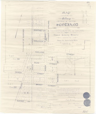
Map of the Village of Scotland, 1894
Description
- Creator
- Jones & Fairchild, Surveyor
- Media Type
- Image
- Item Type
- Maps
- Description
- This item is a reproduction of an 1894 map depicting the village of Scotland in the Townships of Burford and Oakland, County of Brant. It was produced by Jones & Fairchild, Ontario Land Surveyors.
This map is Zoomify enabled! Click on the map to zoom in and pan around so that you can see more details. - Date of Publication
- 1894
- Dimensions
-
Width: 25 in
Height: 30 in
- Map Scale
- 2 chains = 1 inch
- Subject(s)
- Geographic Coverage
-
-
Ontario, Canada
Latitude: 43.0232007197482 Longitude: -80.3744380847168
-
- Copyright Statement
- Public domain: Copyright has expired according to Canadian law. No restrictions on use.
- Recommended Citation
- Map of Scotland, County of Brant (Reproduction), 1894, County of Brant Public Library, Oakland Branch
- Contact
- County of Brant Public LibraryEmail:digitalhistory@brant.ca
Website:
Agency street/mail address:County of Brant Public Library (Paris Branch)
12 William Street
Paris, ON
N3L 1K7 | @brantlibrary


