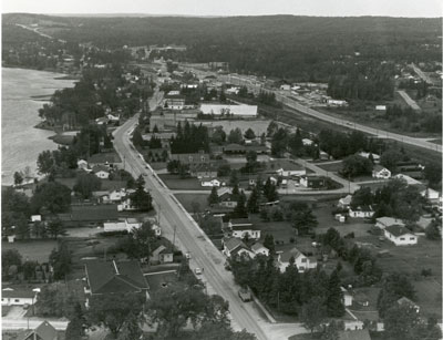
Aerial Photograph of Main Street and Highway 11, Sundridge, circa 1960
Description
- Creator
- Gilland Laurmites
- Media Type
- Image
- Item Type
- Photographs
- Description
- Black and white aerial photograph of Sundridge Ontario during the 1960s. Lake Bernard is on the left of the photograph. In the middle of the image is the Main Street and Highway 11 is on the right side of the photograph.
- Date of Original
- circa 1960
- Date Of Event
- circa 1960
- Dimensions
-
Width: 11 in
Height: 14 in
- Image Dimensions
-
Image Width: 11in
Image Height: 14in
- Subject(s)
- Language of Item
- English
- Geographic Coverage
-
-
Ontario, Canada
Latitude: 45.7668 Longitude: -79.39964
-
- Copyright Statement
- Copyright status unknown. Responsibility for determining the copyright status and any use rests exclusively with the user.
- Contact
- Sundridge - Strong Union PLEmail:sundridgelibrary@gmail.com
Website:
Agency street/mail address:Box 429, 110 Main St.
Sundridge, ON P0A 1Z0