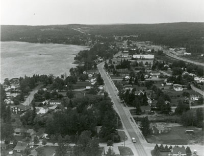
Aerial Photograph of Main Street and Highway 11, Sundridge, circa 1960
Description
- Creator
- Gilland Laurmites, Photographer
- Media Type
- Image
- Item Type
- Photographs
- Description
- Black and white aerial photograph of Sundridge and Lake Bernard. In the middle is the Main Street and Highway 11.
- Date of Original
- circa 1960
- Date Of Event
- circa 1960
- Dimensions
-
Width: 14 in
Height: 11 in
- Image Dimensions
-
Image Width: 14in
Image Height: 11in
- Subject(s)
- Local identifier
- Village of Sundridge File
- Language of Item
- English
- Geographic Coverage
-
-
Ontario, Canada
Latitude: 45.7668 Longitude: -79.39964
-
- Creative Commons licence
 [more details]
- Copyright Statement
- Protected by copyright: Uses other than research or private study require the permission of the rightsholder(s). Responsibility for obtaining permissions and for any use rests exclusively with the user.
- Copyright Date
- 1960
- Terms of Use
- For Educational Purposes
- Reproduction Notes
- For Educational Purposes
- Contact
- Sundridge - Strong Union PLEmail:sundridgelibrary@gmail.com
Website:
Agency street/mail address:Box 429, 110 Main St.
Sundridge, ON P0A 1Z0