Map of Strong Township, Machar
Description
- Mystery Question
- Is this all of the map?[Please answer by clicking on the Comments tab]
- Creator
- Unknown, Cartographer
- Media Type
- Image
- Item Type
- Maps
- Description
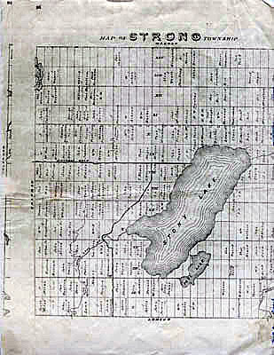
- Photocopy of an early concession map for Strong Township. The township is divided into 14 x 30 plots. Lake Bernard is still Stony Lake at this time. Pool Lake and Lake Wallace are also shown. The main road Distress Road is in the middle of the map. The townships on all sides of Strong are written on the outside.
- Date of Original
- circa 1990
- Date Of Event
- 1870
- Dimensions
-
Width: 8.5 in
Height: 11 in
- Image Dimensions
-
Image Width: 8.5in
Image Height: 11in
- Subject(s)
- Local identifier
- Maps File
- Language of Item
- English
- Geographic Coverage
-
-
Ontario, Canada
Latitude: 45.7668 Longitude: -79.39964
-
- Creative Commons licence
 [more details]
- Copyright Statement
- Protected by copyright: Uses other than research or private study require the permission of the rightsholder(s). Responsibility for obtaining permissions and for any use rests exclusively with the user.
- Copyright Date
- 1985
- Terms of Use
- For Educational Purposes
- Reproduction Notes
- For Educational Purposes
- Contact
- Sundridge - Strong Union PLEmail:sundridgelibrary@gmail.com
Website:
Agency street/mail address:Box 429, 110 Main St.
Sundridge, ON P0A 1Z0