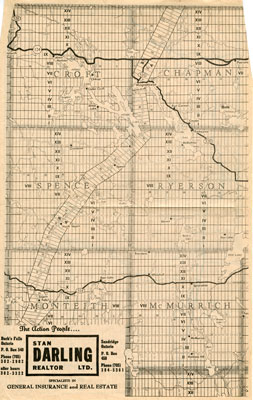
Newspaper Clipping of a Map of Many Townships in the Sundridge Area
Description
- Creators
- Unknown, Cartographer
- Stan Darling Realtor Ltd., Cartographer
- Media Type
- Image
- Item Type
- Maps
- Description
- Newspaper clipping made by a real estate company, Stan Darling Realtor Ltd. This map includes several townships in the Sundridge area. The front page of the map includes: Croft, Chapman, Spence, Ryerson, Montheith & McMurrich. The back of the map features: Strong, Joly, Armour, Proudfoot, Perry & Bethune township.
- Notes
- There's a small rip on the right side of the clipping.
- Date of Original
- circa 1985
- Date Of Event
- circa 1985
- Dimensions
-
Width: 8 in
Height: 14 in
- Image Dimensions
-
Image Width: 8in
Image Height: 14in
- Subject(s)
- Local identifier
- Maps File
- Language of Item
- English
- Geographic Coverage
-
-
Ontario, Canada
Latitude: 45.7668 Longitude: -79.39964
-
- Creative Commons licence
 [more details]
- Copyright Statement
- Protected by copyright: Uses other than research or private study require the permission of the rightsholder(s). Responsibility for obtaining permissions and for any use rests exclusively with the user.
- Copyright Date
- 1985
- Terms of Use
- For Educational Purposes
- Reproduction Notes
- For Educational Purposes
- Contact
- Sundridge - Strong Union PLEmail:sundridgelibrary@gmail.com
Website:
Agency street/mail address:Box 429, 110 Main St.
Sundridge, ON P0A 1Z0