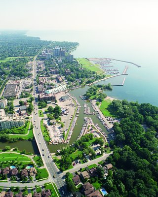
2002 Aerial Photographs of Bronte Harbours
Description
- Media Type
- Image
- Item Type
- Photographs
- Description
- Two aerial photographs showing the mouth of Twelve Mile Creek as it empties into Lake Ontario, Bronte beach and the Bronte Outer Harbour Marina taken in 2002.
Click on "Pages" "Select" to see the 2nd image. It is a view taken from the north, looking down the Creek to Lake Ontario. You can see the construction of the Rebecca Street Bridge over the Creek is underway. - Notes
- These high-resolution photographs are only a few of over 100 that were taken by BP Imaging for the Town of Oakville in 2002. Town of Oakville Heritage Planning has shared these as well as another group of nearly 200 aerial photographs taken in 2005 with the Trafalgar Township Historical Society.
Several other records have been made with a few of the other photographs to this TTHS internet collection but not all have been put on the internet as there are too many. The other selected photographs from the collection are linked together under the "Oakville (including Bronte and the former Trafalgar Township) Aerial Photographs" Groups of Related Records.
All the aerial photographs may be viewed at the TTHS archives where they are digitally stored. - Date Of Event
- 2002
- Subject(s)
- Collection
- Trafalgar Township Historical Society
- Geographic Coverage
-
-
Ontario, Canada
Latitude: 43.40011 Longitude: -79.71632
-
- Copyright Statement
- Copyright status unknown. Responsibility for determining the copyright status and any use rests exclusively with the user.
- Recommended Citation
- 2002 Aerial Photographs of Bronte Harbours
- Contact
-
Trafalgar Township Historical Society Sponsor: Jeff Knoll, Local & Regional Councillor for Oakville Ward 5 – Town of Oakville/Regional Municipality of Halton


