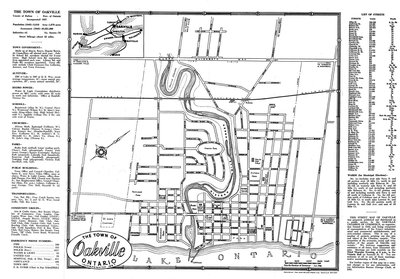
Oakville Town Map, 1948
Description
- Media Type
- Image
- Text
- Item Type
- Maps
- Description
- This 1948 of the town of Oakville lists the schools, churches, public buildings, transportation companies, community groups, emergency municipal phone numbers, municipal wards and street names as well as giving a bit of history and geographic information. The Oakville Chamber of Commerce prepared and published this map to promote "the economic, social and civic welfare of the people of Oakville and vicinity".
Click on "Full" to see the largest map image. (Clicking on the map itself will show you the envelope.) - Notes
- This map was sent to Mr. Stuart Wark and has been kept in the original envelope. To see the envelope, either click on the map image or open up "Page 2".
- Date Of Event
- 1948
- Subject(s)
- Local identifier
- TTHSRMW000221
- Collection
- Trafalgar Township Historical Society
- Geographic Coverage
-
-
Ontario, Canada
Latitude: 43.4473682625124 Longitude: -79.6665048808289
-
- Copyright Statement
- Copyright status unknown. Responsibility for determining the copyright status and any use rests exclusively with the user.
- Recommended Citation
- Oakville Town Map, 1948
- Contact
-
Trafalgar Township Historical Society Sponsor: Jeff Knoll, Local & Regional Councillor for Oakville Ward 5 – Town of Oakville/Regional Municipality of Halton


