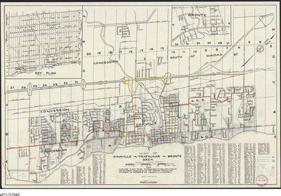
1958 Map Oakville Trafalgar Bronte Area
Description
- Creator
- Kenneth H. McConnell, Creator
- Media Type
- Image
- Text
- Item Type
- Maps
- Description
- This 1958 map of the Town of Oakville has an inset map of Bronte and an inset map of Trafalgar Township. The postal routes and times of delivery are handwritten and drawn on the Town of Oakville section.
The map was obtained from the Canada Post Archives held by the National Library of Canada.
The letter carrier boundaries, the A.M. portion of walk, P.M. portion of walk, local transportation, inner circle, outer circle, Gray Coach Lines are marked by hand using shading, coloured lines or are clear for the Town of Oakville.
The streets of the Town of Oakville are listed and assigned a map grid number. - Notes
- We were trying to ascertain where R.R. 1 Bronte was, what roads/streets it covered in the 1950's. Unfortunately this map doesn't have that information but it is as close as the Canada Post Archives can provide.
In April 2020, we have added a 1918 Post Office "mail contract" asking for bids on the Bronte Rural Route via Merton postal delivery to our internet collection. It is linked under the image in this record for your further information.
This document lays out the route of the Bronte R.R. 1 postal delivery. From the Bronte Post Office, north and west to the border of the townships of Trafalgar and Nelson, north to Dundas Street, east to and then south on Bronte Road, passing through Merton around the Toronto/Hamilon highway (now QEW) intersection to the Bronte Post Office.
This contract indicates that the office of the Post Office Inspector in Toronto held copies of all such area contracts. People looking for further rural delivery routes might look for the archives of this office as well as the archives of Canada Post at Ottawa's Library and Archives Canada. - Inscriptions
- The seal is inscribed: District Director of Postal Services Oper. Sec. June 16 1958 Toronto, Ont.
- Publisher
- Oakville-Trafalgar Chamber of Commerce
- Date of Original
- March 1958
- Map Scale
- 1
- Subject(s)
- Corporate Name(s)
- Kenneth H. McConnell, 119 Colborne St. East Oakville
- Local identifier
- TTACL000371
- Collection
- Trafalgar Township Historical Society
- Language of Item
- English
- Geographic Coverage
-
-
Ontario, Canada
Latitude: 43.4473682625124 Longitude: -79.6665048808289 -
Ontario, Canada
Latitude: 43.4473682625124 Longitude: -79.6665048808289
-
- Copyright Statement
- Copyright status unknown. Responsibility for determining the copyright status and any use rests exclusively with the user.
- Recommended Citation
- 1958 Map Oakville Trafalgar Bronte Area
- Contact
-
Trafalgar Township Historical Society Sponsor: Jeff Knoll, Local & Regional Councillor for Oakville Ward 5 – Town of Oakville/Regional Municipality of Halton


