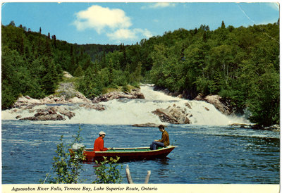
Aguasabon River Falls, Terrace Bay Postcard
Description
- Creator
- Alex Wilson Publications Limited
- Media Type
- Image
- Item Type
- Postcards
- Description
- "Scenic Centre of the North Shore" - Terrace Bay is situated on Highway No. 17 on the north shore of Lake Superior between Thunder Bay and Sault Ste. Marie. It is a welcome stop along the Lake Superior Route, which completely encircles the largest fresh water lake in the world. For here are found the many scenic delights for which the "Circle Route" is famous, such as nearby Aguasabon Gorge and Falls where the Aguasabon River approaches mighty Superior.
- Notes
- This photograph is part of the LSHS Terrace Bay Mill Photographs [Local History] album.
- Dimensions
-
Width: 27 cm
Height: 29 cm
- Image Dimensions
-
Image Width: 15cm
Image Height: 10.3cm
- Subject(s)
- Local identifier
- LSHS Terrace Bay Mill Photographs
- Collection
- Local History
- Language of Item
- English
- Geographic Coverage
-
-
Ontario, Canada
Latitude: 48.78341 Longitude: -87.09996
-
- Copyright Statement
- Copyright status unknown. Responsibility for determining the copyright status and any use rests exclusively with the user.
- Recommended Citation
- Terrace Bay Public Library Archives
- Reproduction Notes
- Please contact the Terrace Bay Public Library.
- Contact
- Terrace Bay Public LibraryEmail:library@terracebay.ca
Website:
Agency street/mail address:13 Selkirk Ave. P.O. Box 369
Terrace Bay, ON P0T 2W0
807-825-3315 x222