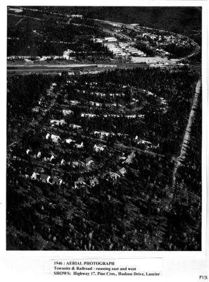
Aerial View of Terrace Bay from 1946
Description
- Mystery Question
- Do you know who took this photograph?[Please answer by clicking on the Comments tab]
- Media Type
- Image
- Item Type
- Photographs
- Description
- This photograph shows an aerial view of Terrace Bay, more specifically of the townsite and railroad, taken in 1946. Shown is Highway 17, Pine Crescent, Hudson Drive, and Laurier Avenue.
- Notes
- Caption: 1946: AERIAL PHOTOGRAPH, Townsite & Railroad - running east and west, SHOWS: Highway 17, Pine Cres., Hudson Drive, Laurier
- Inscriptions
- F13
- Date of Original
- 1946
- Dimensions
-
Width: 21.5 cm
Height: 28 cm
- Image Dimensions
-
Image Width: 20.4cm
Image Height: 25.3cm
- Subject(s)
- Local identifier
- LH Town
- Collection
- Local History
- Language of Item
- English
- Geographic Coverage
-
-
Ontario, Canada
Latitude: 48.78341 Longitude: -87.09996
-
- Donor
- W. Thompson
- Copyright Statement
- Copyright status unknown. Responsibility for determining the copyright status and any use rests exclusively with the user.
- Recommended Citation
- Terrace Bay Public Library Archives
- Reproduction Notes
- Please contact the Terrace Bay Public Library.
- Contact
- Terrace Bay Public LibraryEmail:library@terracebay.ca
Website:
Agency street/mail address:13 Selkirk Ave. P.O. Box 369
Terrace Bay, ON P0T 2W0
807-825-3315 x222


