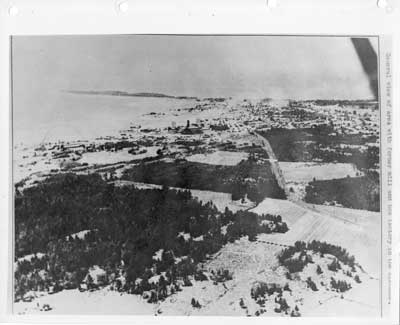
Aerial View of Thessalon, Looking West, circa 1935
Description
- Mystery Question
- Is the area circled in the centre the former Saginaw mill site?[Please answer by clicking on the Comments tab]
- Media Type
- Image
- Item Type
- Aerial photographs
- Description
- This is a reproduction of a black and white aerial photo of Thessalon. The photo appears to have been taken from the east side of town looking south and west towards the waterfront and the peninsula beyond.
Photo inscription notes indicate one of the former mills and box factory are visible in the distance. It appears as if someone has taken a pencil and circled two areas along the waterfront that may be the sites denoted.(upper left quadrant of photo). The foreground is a mix of forest and open land.
- Notes
- This unmarked and undated photo was located in miscellaneous municipal files and permission was granted to scan this photo to add to our local collection.
- Inscriptions
- The typed inscription along the right hand side of the photo reads "General view of area with former mill and box factory in the distance."
- Date of Original
- circa 1935
- Dimensions
-
Width: 10 in
Height: 8 in
- Subject(s)
- Local identifier
- Thessalon Municipal Office
- Language of Item
- English
- Geographic Coverage
-
-
Ontario, Canada
Latitude: 46.25006 Longitude: -83.5666
-
- Copyright Statement
- Protected by copyright: Uses other than research or private study require the permission of the rightsholder(s). Responsibility for obtaining permissions and for any use rests exclusively with the user.
- Contact
- Heritage Park MuseumEmail:thessalonlib@hotmail.com
Agency street/mail address:P.O. Box 425
Thessalon, ON
P0R 1L0

