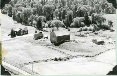
Aerial View of Seabrook Farm, circa 1950
Description
- Mystery Question
- What year was this photo taken?[Please answer by clicking on the Comments tab]
- Media Type
- Image
- Item Types
- Photographs
- Aerial photographs
- Description
- This is a black and white aerial photo of the Seabrook Farm, S.W.1/4 of Lot 15. Four buildings can be seen in the centre of the photo including a two-story house, a barn, and two other out buildings.
Large trees fill the background, while fenced fields fill the foreground of the photograph.
- Date of Original
- Circa 1950
- Dimensions
-
Width: 5.5 in
Height: 3.75 in
- Subject(s)
- Local identifier
- Sunnyside Tweedsmuir
- Collection
- Local History
- Language of Item
- English
- Geographic Coverage
-
-
Ontario, Canada
Latitude: 46.25006 Longitude: -83.5666
-
- Creative Commons licence
 [more details]
- Copyright Statement
- Public domain: Copyright has expired according to Canadian law. No restrictions on use.
- Contact
- Thessalon Union Public LibraryEmail:thessalonlib@thessalonlibrary.ca
Website:
Agency street/mail address:187 Main St. Box 549
Thessalon, ON P0R 1L0


