Aerial View of Fairview Stock Farm, Thessalon, 1966
Description
- Media Type
- Image
- Item Type
- Photographs
- Description
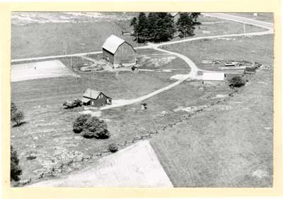
- This is a black and white aerial photo showing the Fairview farm. The photograph features a barn, what appears to be a home, and various outbuildings.
The road in the top right hand corner of the image may be Hwy 17.
- Notes
- The beef farm was originally owned by the Mortimer family in the 1800s.
This photo can be found in the Tweedsmuir History created by the Princess Elizabeth Women's Institute.
- Date of Original
- 1966
- Dimensions
-
Width: 6 in
Height: 4 in
- Subject(s)
- Collection
- Local history
- Language of Item
- English
- Geographic Coverage
-
-
Ontario, Canada
Latitude: 46.25006 Longitude: -83.5666
-
- Creative Commons licence
 [more details]
- Copyright Statement
- Protected by copyright: Uses other than research or private study require the permission of the rightsholder(s). Responsibility for obtaining permissions and for any use rests exclusively with the user.
- Contact
- Thessalon Union Public LibraryEmail:thessalonlib@thessalonlibrary.ca
Website:
Agency street/mail address:187 Main St. Box 549
Thessalon, ON P0R 1L0
Comment on this item
Create electronic postcard
Full Image
Groups of Related Records
Other Web sites/External links
