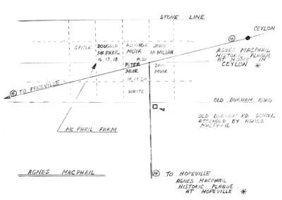
Map of Agnes Macphail locales in Grey County Part 1
Description
- Creator
- [Huston, Archie?], Illustrator
- Media Type
- Image
- Item Type
- Maps
- Description
- Hand drawn map of significant places relating to Agnes Macphail. The map identifies farms near the McPhail's, at Six Corners in Artemesia Township, as well as the location of Durham Rd. School which Agnes Macphail attended and two historical plaques erected in her honour.
- Date of Original
- c.1995
- Date Of Event
- 1890-1954
- Dimensions
-
Width: 28 cm
Height: 22 cm
- Subject(s)
- Local identifier
- 996.023.013a
- Language of Item
- English
- Geographic Coverage
-
-
Ontario, Canada
Latitude: 44.2297025764246 Longitude: -80.5854034423828
-
- Copyright Statement
- Protected by copyright: Uses other than research or private study require the permission of the rightsholder(s). Responsibility for obtaining permissions and for any use rests exclusively with the user.
- Copyright Holder
- Archie Huston
- Terms of Use
- Reproduction of digital objects is restricted to fair use for personal study or research, any other use must be done with permission of copyright holder.
- Contact
- South Grey Museum


