Northern Lights Country West
Description
- Media Type
- Image
- Item Type
- Maps
- Description
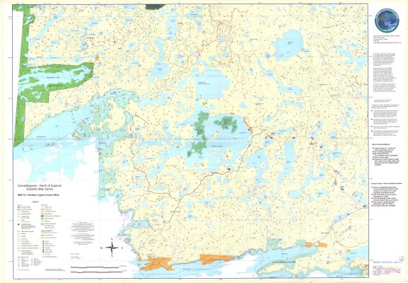
- Recreation Maps ; Contour Maps ; Northern Light Lake Area ; Provincial Parks ; Snowmobile Trails ; Recreation Trails ; Camping Areas ; Boat Launches
- Notes
- CrimeStoppers - North of Superior Explorer Map Series
Map housed at the Brodie Resource Library - Publisher
- Kestrel Forestry
- Date of Publication
- 2000
- Map Scale
- 1:50,000
- Subject(s)
- Corporate Name(s)
- Crime Stoppers ; North of Superior Tourist Association
- Local identifier
- Map 1A
- Collection
- Maps
- Language of Item
- English
- Geographic Coverage
-
-
Ontario, Canada
Latitude: 48.14979 Longitude: -90.26688 -
Ontario, Canada
Latitude: 48.09978 Longitude: -90.68351 -
Ontario, Canada
Latitude: 48.26647 Longitude: -90.6502 -
Ontario, Canada
Latitude: 48.28308 Longitude: -90.96692 -
Ontario, Canada
Latitude: 48.36653 Longitude: -90.5335 -
Ontario, Canada
Latitude: 48.29977 Longitude: -90.6502
-
- Copyright Statement
- Protected by copyright: Uses other than research or private study require the permission of the rightsholder(s). Responsibility for obtaining permissions and for any use rests exclusively with the user.
- Copyright Date
- 2000
- Copyright Holder
- Thunder Bay District Crime Stoppers Inc., North of Superior Tourism, The Friends of Northern Lights Country
- Copyright Holder Contact Information
- www.nosta.on.ca 807-626-9420
- Contact
- Thunder Bay Public LibraryEmail:research@tbpl.ca
Website:
Agency street/mail address:Brodie Resource Library
216 South Brodie Street
Thunder Bay, ON
P7E 1C2